Traffic signal data format
A/B Street uses a JSON format to describe how a single intersection with traffic signals is configured. This format changes more frequently, but the software will automatically upgrade a signal described in an old format. This way, players can save their edits to a map and, months later, still use the same edits with a new version of A/B Street. (The only exception is when OpenStreetMap IDs change; if a way near the intersection is split and assigned a new ID, we make no attempt to handle this.)
The format is complicated, so let's break down some of the concepts used in it.
Turns
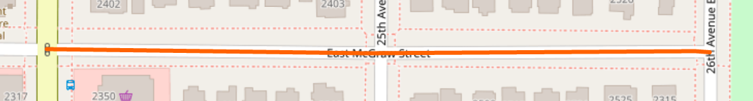
We first need a way to describe a movement between two road segments. Let's use https://www.openstreetmap.org/node/53219808, the intersection of 24th Ave E and E McGraw St in Seattle as an example.
Directed road segments
So first let's identify a single road segment. For this example, let's describe the eastbound direction of the west side of McGraw St, which is https://www.openstreetmap.org/way/804788512 in OSM. As you can see, this way hits 3 intersections. We just want to describe the segment between 24th and 25th Ave. Looking at the list of nodes for that way in the order defined in OSM, we see it goes from https://www.openstreetmap.org/node/53219808 to https://www.openstreetmap.org/node/1709143541. Note that the intermediate nodes used as control points for the shape of the road or as crosswalk nodes are ignored. So, we can describe this segment by using the way's ID and the first and last node ID.
{
  "osm_way_id": 804788512,
  "osm_node1": 53219808,
  "osm_node2": 1709143541,
  "is_forwards": false
}
Finally, we have to say which direction of this road segment we're talking
about. The order of the nodes in OSM is arbitrary; in this case, the road points
from the traffic signal we're talking about to another intersection. But we want
to refer to the inbound / eastbound direction of this road. So we say
"is_forwards": false to indicate the opposite of the direction specified by
OSM. This is the same concept as "forward & backward" as defined in the
OSM wiki.
Turns for vehicles
So now let's describe the left turn from E McGraw to 24th going southbound. It looks like this:
{
  "from": {
    "osm_way_id": 804788512,
    "osm_node1": 53219808,
    "osm_node2": 1709143541,
    "is_forwards": false
  },
  "to": {
    "osm_way_id": 6470476,
    "osm_node1": 53128048,
    "osm_node2": 53219808,
    "is_forwards": false
  },
  "intersection_osm_node_id": 53219808,
  "is_crosswalk": false
}
You specify the from and to fields using the directed road segment ID.
Additionally, you specify which intersection the traffic signal is at --
53219808 in this case -- and set is_crosswalk to false to indicate a turn
for vehicles or cyclists on the road.
Crosswalks
Why is the format above so repetitive? The reason is to be able to also specify
movements along crosswalks in the intersection. The from and to directed
road segments refer to one half of a road, so they can be used to identify one
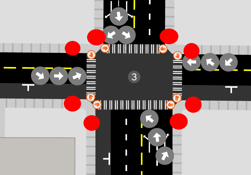
sidewalk or another. From this diagram, you can see how there are 8 different
start or end points for crosswalks at this intersection:
TODO: Walk through an example of a single crosswalk. I hope the explanation of the format above suffices, for now.
Stages
Now that we understand how to describe turns, we can describe the sequence of stages that a traffic signal cycles through. Each stage specifies the turns that are protected and permitted. Protected turns have priority (a green light), and no two protected turns in the same stage can cross each other. Permitted turns are allowed only if there's no oncoming traffic -- so this could mean a right turn on red or an unprotected left turn with a flashing arrow. Note that crosswalks always must be defined as protected, which means any vehicle turns that intersect with the crosswalk have to be specified as permitted. This captures the semantics in the US that turning vehicles must always yield to pedestrians when the crosswalk signal is on.
A single traffic signal cycles through the same list of stages over and over.
Each stage also specifies its duration with the stage_type. The simple example
is "Fixed": 45, meaning this stage always lasts exactly 45 seconds. A stage
can also have variable timing, also known as actuation. The format is
"Variable": [15, 2, 10]. This stage would last a minimum of 15 seconds, but it
may last an additional 10 seconds, up to a maximum of 25 seconds. If there are
no vehicles or pedestrians trying to make protected turns after 15 seconds, the
stage ends. If there are, then the stage is extended by 2 seconds, and the same
check repeats, until the maximum of 25 is reached.
The full example
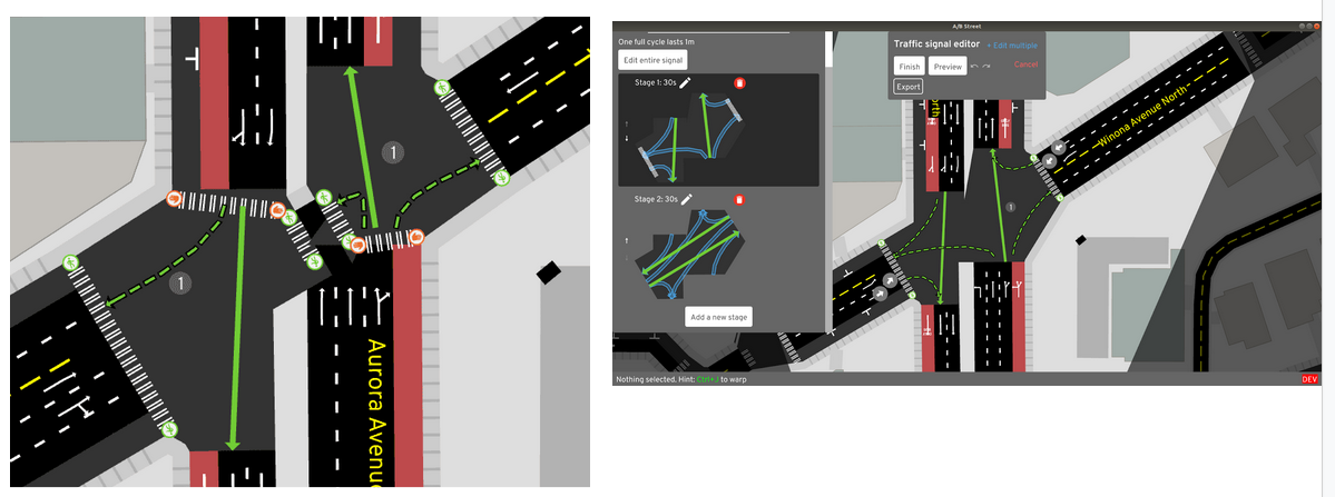
Understanding everything above means you should be able to interpret what https://github.com/a-b-street/abstreet/blob/599c7b6d6bc078312e5ea9f57d3391be9568ef83/traffic_signal_data/data/53219808.json means. The rendering in A/B Street looks like this:
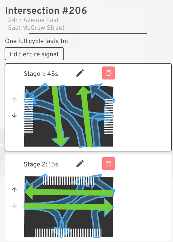
There are two stages. The first lasts 45 seconds and allows north/south movement. Left turns onto McGraw are permitted after yielding. Since the north/south crosswalks are also enabled, all right turns also have to yield. The second stage lasts only 15 seconds and lets east/west traffic move. Left turns are also unprotected here.
Limitations
In reality, many traffic signals use different configuration during rush hour, late at night, on weekends, etc. There's some planned work to model one intersection having different plans.
Many intersections in Seattle now use leading pedestrian intervals, which enable a crosswalk signal to give pedestrians a head-start into the intersection before vehicles start to turn. You can model this in A/B Street by adding an extra stage that only enables the crosswalks and lasts a few seconds, followed by a stage allowing both the crosswalks and vehicle turns. We could explicitly add a parameter for LPI duration, but it would complicate the format, so this "flattened stage" format will work for now.
You'll notice the format for specifying turns works at the granularity of the entire road, not individual lanes. Most of the time, this is fine -- vehicles will only use the turn lanes available. But in some cases, we may want to distinguish two groups of vehicles moving the same direction by the lane type. In particular, sometimes there's a bidirectional protected cycle-track on one side of the road with its own dedicated signal:
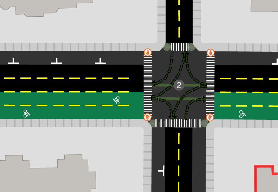
A/B Street can't model this as having a separate signal yet.
Complications with importing other data
External software like vol2timing can provide much better signal configuration than A/B Street's default heuristics. We will encounter at least two major challenges to import it.
Crosswalks
A/B Street currently does not use sidewalks, foot-paths, and crosswalks that are explicitly drawn as separate OSM ways. Instead, it makes many guesses for which roads have a sidewalk and creates many, many crosswalks. See https://github.com/a-b-street/abstreet/issues/485 for some examples of crosswalks that should not be created, but currently are.
When A/B Street imports traffic signal configuration, it validates that all possible turns at the intersection are captured by at least one stage. The problem here will be that other software may not list as many crosswalks as A/B Street expects.
Intersection merging/consolidation
OSM models bidirectional roads with some physical median as two one-ways. When these divided one-ways cross a regular road, the intersection is split into two intersections with a very short "road" in between. When two pairs of divided one-ways cross, the intersection has four nodes and short "roads" in between. This wreaks havoc in A/B Street, making the intersection geometry look strange, making it hard to edit the two or four uncoordinated traffic signals around the intersection, and causing vehicles to get stuck in the short "roads".
One solution that's promising is for A/B Street to consolidate those nodes and short "roads" into one big intersection, capturing how a human would intuitively view the area. One case where this works well is https://www.openstreetmap.org/#map=19/47.68264/-122.34426. See the before and after:
Unfortunately this process doesn't work for many more cases, so it's not enabled by default yet. Preserving turn restrictions defined by OSM and getting good results for the geometry of the consolidated intersection is hard.
In the meantime, all of this complicates the traffic signal format, because it's unclear how to specify road segments when A/B Street will arbitrarily delete some of the node IDs when it imports.