Lake Washington Blvd Stay Healthy Street
Draft, updated May 7, 2020 by Dustin Carlino (dabreegster@gmail.com)
In April 2020, Seattle Department of Transportation started rolling out Stay Healthy Streets, restricting roads to through-traffic to give people walking and biking more space for social distancing. Seattle Neighborhood Greenways soon proposed extending this to a 130-mile network.
Selecting the streets requires some planning:
These streets were selected to amplify outdoor exercise opportunities for areas with limited open space options, low car ownership and routes connecting people to essential services and food take out. We also ensured street closures did not impact newly opened food pick up loading zones, parking around hospitals for service for health care professionals, and bus routes.
I've spent the last two years building A/B Street, software to explore the impacts of changes like this on different modes of transportation. So, let's try implementing part of the proposed network and see what happens!
Lake Washington Blvd
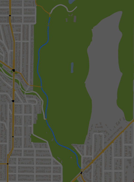
Let's start with one part of the proposal, closing Lake Washington Blvd to cars through the Arboretum. There's already a multi-use trail alongside this stretch, but its width makes it difficult to maintain 6 feet from people. There are some parking lots that become inaccessible with this proposal, but they're currently closed anyway.
First attempt
Let's get started! If you want to follow along, install A/B Street, open sandbox mode, and switch the map to Lake Washington corridor. Zoom in on the southern tip of the Arboretum and hop into edit mode. We can see Lake Washington Blvd just has one travel lane in each direction here. Click each lane, convert it to a bike lane, and repeat north until Foster Island Road.
When we leave edit mode, the traffic simulation resets to midnight. Nothing really interesting happens until 5 or 6am, so we'll speed up time. Watching the section of road we edited, we'll only see pedestrians and bikes use this stretch of road. If we want, we can click an individual person and follow along their journey.
Something's weird though. There's lots of traffic cutting northbound through the neighborhood, along 29th, Ward, and 28th. We can open up the throughput layer to find which roads have the most traffic. More usefully, we can select "compare before edits" to see what roads are getting more or less traffic because of the road we modified. As expected, there's much less traffic along Lake Wash Blvd, but it's also clear that lots of cars are now cutting through 26th Ave E.
Traffic calming
Let's say you want to nudge traffic to use 23rd Ave, the nearest north/south arterial, instead. (A/B Street is an unopinionated tool; if you have a different goal in mind, try using it for that instead.) In this simulation, drivers pick the fastest route, so we could try lowering speed limits or make some of the residential streets connecting to Madison one-way, discouraging through-traffic. In reality, the speed limit changes could be implemented through traffic calming or cheap, temporary alternatives.
Next steps
I'm working to model "local access only" roads in A/B Street, and I'll describe how to measure the impact on travel times. Stay tuned to see more of the proposed network simulated, and get in touch if you'd like to help out!